2024 Club Trail Map
The 2024Trail Map is available now
During the season, maps are available at Heath’s Hardware, Haffners, DaSilva’s, Village Kitchen, Village Emporium (Mobile), Moultonboro Country Store and Skelley’s.
Click here to order trail maps online
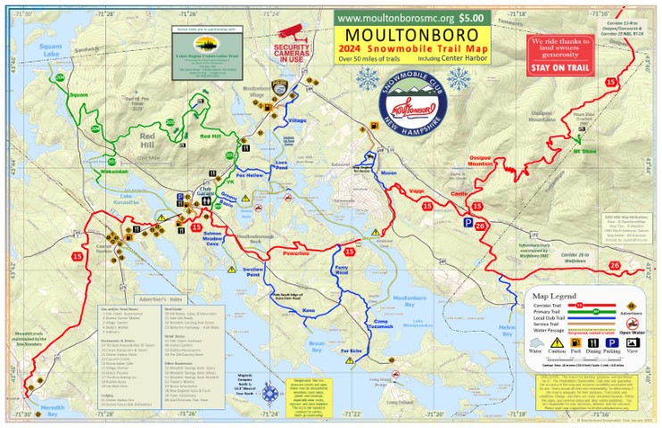
The 2024 Moultonboro Snowmobile Club Trail Map shows the path of State Corridor 15 from Center Harbor to Ossipee and Corridor 26 from the LRCT Parking lot on Route 171 towards Wolfeboro. Also, Primary Trails 201 and 204, club trails, service spurs and lake access points. Popular routes through Red Hill and the the western half of the Ossipee Mountains are mapped with GPS accuracy.
The map is 11×17″, folded and printed on 80# gloss text paper.
Maps sells for $5, available at merchants or from this website (add $1.50 shipping) The profit from map sales is helps to pay for club operations. Thanks for your support.
Trail maps are available at local merchants or Click Here to order maps online
In-season, trail maps are available at these business locations.
- Haffner’s Fuel – Corridor 15 on RT 25, across from Lake Kanasatka
- daSilva Motorsports – Greens Corner Service Trail – Corner of Rte. 25 and M’boro Neck Rd
- E.M. Heath’s Hardware- Rte. 25, Center Harbor – Center Harbor Spur off Corridor 15
- Village Kitchen – Rt 25, Moultonboro – on Primary 201/VK trail at Red Hill
- Village Station Mobile – Service trail off of Village Trail
- The Old Country Store – Rte. 25, Moultonboro – Walk to from Village Mobile Station
- Skelley’s Market – 374 Gov Wentworth Hwy, End of Mason Trail
Please visit our sponsors and thank them for supporting our club
Send trail map suggestions and corrections to trailmap@moultonborosmc.org
NH Snowmobile Association Interactive Trail Maps https://nhsa.evtrails.com/# (note, while the MSC has submitted its trails to NHSA for the map, it may be out of date and does not reflect current conditions.
E-Maps for phones and GPS units. Good for areas without cellular data coverage: http://www.gpstrailmasters.com/content/goomap/snow-map_E.html
2024 Map List of Changes and other notes
- Trail from Center Harbor to Meredith is open.
- No trail reroutes occurred between 2023 and 2024
2023 Map List of Changes and other notes
- N/A – Trail is OPEN – Trail from Center Harbor to Meredith is closed. Work is underway to reroute around the blockage but as of map publication, the trail is closed.
- There is a new route off the East side of Kanasatka and through the Toy Box store. Follow signs.
- There is a new exit off the east side of Lees Pond, crossing Blake Road and reconnecting with the trail through the school property.
- There is a new route from Far Echo to cross Moultonboro Neck Rd.
2022 Map List of Changes and other notes
- Added Ferry Road Trail
- Reroute in Power Line Trail in sand pit to avoid new rock pile
- Reroute in access point to Winnipesaukee from Lees Pond Trail
- Show reroute of Corridor 15 in Meredith and added club trail to Lake Winnipesaukee
- Added diamonds to show changes in most recent map
2021 Map List of Changes and other notes
- The word “Trail” has been removed from most trails to reduce clutter.
- Corridor 15 from Kanasatka to the BP gas station is in a new location due to new house construction. Come off Lake Kanasatka west of the previous trail and cross just west of the BP station, where the crossing was several years ago.
- The trail between Moultonboro Neck Rd at Shaker Jerry Rd and Kona Wildlife area, opened for the 2020 season is now on the map. This includes 1000 feet along Kona Farm Road. Ride off the road and on the south side only. There is also a short reroute along Swallow Point Rd.
- The Village Trail crossing of Old Rt 109 near Cup and Crumb is moved south about 150 feet due to a memorial garden built on the old route. Ride on the right side of the road.
- The trail between the Subway and Lake Kanasatka is closed because a land-owner withdrew permission to cross her land.
- The service access trail from the Village Trail to Village Station Irving now routes back into the woods after coming out at Huggins Medical Clinic. This trail was widened and we no longer pass between the Taylor House and the old Well.
- The trail where Corridor 15 crosses Winnipesaukee from the powerline and Ambrose cove is routed off the property owner’s driveway and lawn and now continues under the newly excavated powerline.
2020 Map List of Changes and other notes
- The Putnam trail is renamed the VK trail (VK references the Village Kitchen)
- The trail between the VK trail and Lake Winnipesaukee or Lees Pond is renamed to Evergreen Trail, referencing Evergreen Island, located in Winnipesaukee.
- Lees Pond Trail is a short trail going from Evergreen Trail to Lees Pond.
- The Carriage Trail and all access to the Castle in the Clouds Carriage House is closed for 2020. The normal trail is washed out and we are no longer permitted to use the paved toll road.
- The trail between Moultonboro Neck Rd at Shaker Jerry Rd and Kona Wildlife area is open. This includes 1000 feet along the south side of Kona Farm Road.
- After the map was published, we lost access to the trail between Burton Rd and the rear of the Subway. Signs are in place at north side of the Subway property to restrict access.
- The Murphy’s Village Store and Irving gas station has a new owner and is renamed to the Village Station. The access trail, off the Village Trail, passes between the White Taylor House and the old well.
- The map has a new notice that security cameras are in use. A number of our landowners are using cameras to monitor for people that sled off-trail.
2019 Map List of Changes and other notes
- The trail from the LRCT owned Ossipee Trail Parking Lot on 171 towards Wolfeboro is open again after being closed for two years.
- The Carriage Trail (Toll Road) is shut down and removed from the map. We expect the high-mountain spur to the Carriage House, on the Castle Grounds will be open, but construction was not finished at the time of printing.
- The Swallow Point Trail, is shut down from Corridor 15, at the corner of Moultonboro Neck Rd and Shaker Jerry Road to Kona Farm Road, after the Swallow Point Association withdrew its permission for use. The 2017 shut down of the connection to Kona Woods and Far Echo via Morrill Rd continues. Club members south of the blockage can access other club trails via lake access points at Smith Cove and Salmon Meadow Cove,
- Please shut down engines when horses are present on the Mason Trail, near Skelley’s Market on Route 109. The property owner owns a horse farm and sells horse rides, especially on weekends, on the trails that they share with the club. The route to Skelley’s fuel and food is at risk of closure if snowmobilers continue scare the horses.
- The Primary Trail 204 that goes on the west side of Red Hill and Bean Road to Squam Lake does not continue into Sandwich anymore. You can still get on Squam Lake at Harvard Road. Using a trailer may be the best way to ride Sandwich Notch Road,
- Renamed Kona Trail to Kona Woods Trail. It starts near Kings Court and ties into Far Echo Trail at the Smith Cove lake access point, on the Camp Tecumseh property.
- Rerouted the portion of Kona Woods Trail on the Eastern side of Moultonboro Neck Road. The new property owner built a house and their driveway is where the trail used to go. They were kind enough to allow this important route to stay open by moving the trail off their driveway. Please be extra polite in this first year “trial period”.
- Lee Trail is now named separate from a newly named Agnar trail, going from club trail 201 to a Lake Winnipesaukee access near Evergreen and Badger Island. Lee Trail branches from Agnar Trail and goes to Lees Pond.
- The access to the eastern side of town via Corridor 15 at Ambrose Cove has a slightly altered route. A storage container is in the path of the former trail. We have permission to cross the corner of a paved driveway to bypass the blockage. Please don’t spin your track. It will tear up the driveway and a risk trail closure of this critical path that connects the east and west side of town.
2018 Map List of Changes
- Added Carriage Trail and listed hours open
- Renamed Shaw Trail to Ossipee Trail
- Moved Shaw Trail to extension off Corridor 15 that goes to top of Shaw Mountain
- Marked Kona Trail closed from Kona State Land to Morrill Rd.
- Marked Corridor 26 towards Wolfeboro from Castle Parking lot with “Follow signs for rerouted trail” (was closed last year – may be open – but route not confirmed)
- Moved business marker 8 (formerly Provisions) to Castle Carriage House Restaurant
- Changed Squam note to “Primary Trail 204 to Sandwich Notch and West to Corridor 8” – Route to Ossipee from Sandwich Notch is closed this year
- Added Club Garage logo, label and toilet symbol – We have a public toilet this year!
- Added Caution sign to west side of Goodwin Island – dueling bubblers causing problems
- Updated LRCT credit with new address and phone numbers
- Added “watch for horses sign” and logo on Mason Trail – riders should slow or stop
- Updated map in January, printed on 8.5×11 paper. Removed small items and enlarged labels.